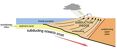
 | This schematic cross-section of subduction zone shows the relationship of the plates to sediment, the surrounding ocean and the land mass. |
Researchers at Yale and the University of Washington report that great earthquakes, like the one in Sumatra in 2004, may be caused by the build-up of sediment on top of subduction zones, suggesting a new way to forecast these most severe earthquakes.
Subduction zones are the areas of the seafloor just offshore where two tectonic plates collide, with one plate pushing over and one under the other. The most severe earthquakes in recent history -- in Indonesia in 2004, Alaska in 1964, Chile in 1960 and the Pacific Northwest in 1700 -- occurred at subduction zone faults. In the United States, there are subduction zones along the Aleutian margin of Alaska and the Cascadia margin bordering the west coast of the Pacific Northwest.
"Seismologists have long known that the motion of the plates at subduction zones can be smooth and steady in some areas, and sticky and unsteady in other areas," says Mark Brandon, professor of geology and geophysics at Yale and senior author on the paper appearing in the February issue of the journal Geology.
Earth plates move, and earthquakes ensue in these subduction zones. But some quakes are far more damaging than others. Doctoral student Christopher W. Fuller and associate professor Sean D. Willett at the University of Washington and Brandon at Yale believe they have found a key to identifying specific areas within a subduction zone that will produce the most severe damage when they rupture.
The Earth's surface is laced with about 32,000 miles of subduction zones, and the motion along the margins of the zones averages a slip of about two inches per year. However, where the margins stick and then rip apart into earthquakes, there have been displacements as much as 65 feet over many hundreds of miles in as little as 10 minutes, according to Brandon.
The team used computer simulations to determine how the upper plate deformed above a subduction zone fault.
"The leading edge of the overriding plate will continually deform, much like snow in front of a snow plow blade," according to Brandon. "As one plate moves under another and the upper plate deforms, it breaks up adhesion on the subduction fault and reduces its ability to generate greater earthquakes."
Past research has shown that as a subducting plate slides beneath an upper plate, stress builds where the plates meet and stick, and the upper plate warp creates a wedge and a bowl-shaped depression, called a forearc basin. Beneath the sea, this basin fills with sediment that empties from nearby rivers. It appears that the most severe subduction zone earthquakes occur in areas where such sediment-filled basins are found.
These current simulations showed, however, that when sediment was deposited on top of the overriding plate, it reinforced the edge of the plate and caused it to "stick," directly above where the earthquake would happen so that it no longer deformed internally. The researchers speculate that this allows the subduction zone to remain at rest for longer periods of time and thus to "stick," making it more prone to earthquake events.
"This phenomenon is analogous to a mayonnaise jar in the refrigerator. The lid opens easily if you use it every day. But if you open the jar infrequently, adhesion will make it difficult to open," explains Brandon. "A sharp tap on a counter breaks the adhesion and the lid opens with a quick spin. In the Earth, the earthquake marks the breakdown of adhesion on the subduction zone."
Fuller, the lead author on the paper, adds, "Over millions of years, the sediment typically piles to great depths, from a half-mile to nearly two miles, and in rare cases it might reach three miles deep. The increased weight of the sediment stops deformation from occurring."
This modeling could have implications for forecasting areas within a subduction zone, such as Cascadia, where great earthquakes are the most likely to occur. But the work is not applicable to every subduction zone because each has different characteristics, explains Fuller. "You have to understand the nature of basins and how they work in each area before you can use them as an interpretive tool."
This research was funded by the National Science Foundation.
-- By Janet Rettig Emanuel
T H I S
Scientists say sediment layer may
forecast greatest earthquakes W E E K ' SS T O R I E S
![]() Summer program will send students to Singapore
Summer program will send students to Singapore![]()
![]() Scientists say sediment layer may forecast greatest earthquakes
Scientists say sediment layer may forecast greatest earthquakes![]()
![]() Yale receives $5.4 million NIH grant . . .
Yale receives $5.4 million NIH grant . . .![]()
![]() Trips to Afghanistan kindle student's love of parents' homeland
Trips to Afghanistan kindle student's love of parents' homeland![]()
![]() 'How many deaths? ... How many injuries?'
'How many deaths? ... How many injuries?'![]()
![]() Yale composer is elected the president of scholarly academy
Yale composer is elected the president of scholarly academy![]()
![]() ENDOWED PROFESSORSHIPS
ENDOWED PROFESSORSHIPS
Dirk Bergemann is appointed . . . Campbell Professor of Economics![]()
Philip Haile is named the Ford Foundation Professor of Economics![]()
Urry designated the Israel Munson Professor of Physics and Astronomy![]()
Warner is named the Avalon Professor of the History of Medicine![]()
![]() Symposium pays tribute to noted architect Philip Johnson
Symposium pays tribute to noted architect Philip Johnson![]()
![]() Film explores evolution vs. intelligent design
Film explores evolution vs. intelligent design![]()
![]() Yale affiliates to be among featured guests at LEAP fundraising dinner
Yale affiliates to be among featured guests at LEAP fundraising dinner![]()
![]() New test uses amniotic fluid to predict possibility of premature birth
New test uses amniotic fluid to predict possibility of premature birth![]()
![]() Sex of fetus shown to affect severity of symptoms in women with asthma
Sex of fetus shown to affect severity of symptoms in women with asthma![]()
![]() Analyzing proteins in urine can help diagnose, classify preeclampsia'
Analyzing proteins in urine can help diagnose, classify preeclampsia'![]()
![]() Exhibit, symposium focus on two 'Witnesses to War and Revolution'
Exhibit, symposium focus on two 'Witnesses to War and Revolution'![]()
![]() The 60-year history of the United Nations is celebrated in new library exhibit
The 60-year history of the United Nations is celebrated in new library exhibit![]()
![]() Expert on global environmental issues named Distinguished Visiting Fellow
Expert on global environmental issues named Distinguished Visiting Fellow![]()
![]() Issues of chronic illness explored in international conference
Issues of chronic illness explored in international conference![]()
![]() Readings celebrate 'London's River' in verse and prose
Readings celebrate 'London's River' in verse and prose![]()
![]() Campus Notes
Campus Notes![]()
Bulletin Home|Visiting on Campus|Calendar of Events|In the News![]()
Bulletin Board|Classified Ads|Search Archives|Deadlines![]()
Bulletin Staff|Public Affairs|News Releases|
E-Mail Us|Yale Home